20/09/2026
UK Weather Outlook: Mild Start, Midweek Rain and Cooler Nights
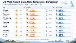
The UK is set for a generally mild and fairly settled start to the week, with sunny spells and above-average daytime temperatures in many areas. Tuesday is expected to be one of the warmest days, particularly across southern and eastern England. A spell of Atlantic rain is likely to move across the country around the middle of the week, bringing wetter and breezier conditions before brighter weather returns. Overnight temperatures will vary considerably, with some clear nights turning noticeably chilly, especially in rural areas. Overall, temperatures are expected to range from around 15–25°C by day and roughly 5–15°C overnight, depending on location and cloud cover.
UK Weekly Forecast
Monday: Bright Start for Many
Typical daytime temperatures: 17–23°C
Monday should be mostly dry across England and Wales, with sunny spells developing through the day. Scotland and Northern Ireland are more likely to see cloudier conditions, with some patchy rain possible at times.
Temperatures should be mild to warm, particularly across central, southern and eastern England where highs could reach around 22–23°C. Northern areas will generally be cooler.
Tuesday: Dry, Bright and Warmer
Typical daytime temperatures: 18–25°C
Tuesday currently looks like one of the better days of the week. Many areas should stay dry with variable cloud and some good spells of sunshine.
Temperatures are expected to rise, with southern and southeastern England potentially reaching around 24–25°C. Scotland and northern England should remain cooler but still relatively mild for late September.
Wednesday: Atlantic Rain Moves In
Typical daytime temperatures: 16–22°C
Conditions are expected to become more unsettled during Wednesday as a weather front moves in from the Atlantic. Outbreaks of rain are likely to spread across northern and western areas before moving further southeast.
Some heavier bursts of rain are possible, especially across northern parts of the UK. Temperatures are likely to fall back somewhat compared with Tuesday, particularly beneath persistent cloud and rain.
Thursday: Brighter Skies Return
Typical daytime temperatures: 16–21°C
Thursday should see conditions improve behind the front, with drier and brighter weather returning to many areas. Sunny spells are likely, although temperatures may feel slightly fresher.
Where skies remain clear overnight, temperatures could fall quite sharply, giving a noticeably chilly start in some rural areas.
Friday: Settled South, More Changeable Northwest
Typical daytime temperatures: 16–22°C
Friday currently looks more settled across southern parts of the UK, with dry and bright conditions possible for much of the day.
Further north and west, there is a greater chance of cloud, occasional rain and breezier weather as Atlantic systems remain nearby. Southern areas are likely to remain the mildest.
Weekend: Atlantic Influence Increasing
Typical daytime temperatures: around 15–21°C
Confidence becomes lower heading into the weekend. Southern and eastern areas may remain drier for longer, while Scotland, Northern Ireland and northwest England are more likely to see further spells of cloud, rain and occasionally stronger winds.
Temperatures should generally remain close to or slightly above late-September levels, although wetter and windier areas will feel cooler.
Overall Outlook
A generally settled and mild to warm start to the week is expected, with Tuesday likely to bring the highest temperatures, potentially reaching around 24–25°C in parts of southern England.
Temperatures should ease back from Wednesday onwards as Atlantic weather becomes more influential. Northern and western areas will remain most exposed to periods of rain, while southern and eastern parts of the UK should see the best of the drier and warmer conditions.
Expected UK daytime range through the week: approximately 15–25°C, depending on location and day.